

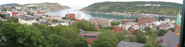
I decided to start the Thanksgiving weekend off with a day trip to Bell Island and then Cape St. Francis. Both destinations are within an hour drive from St. John's, but once there, certainly feel a world away. The day started early. I left Burtons Pond at 8:30am and made my way (past the overpass) out of the city. I wanted to leave early so that I could stop at Beachy Cove Restaurant in Portugal Cove for some breakfast. I have been wanting to sample toutons - fried bread dough topped with molasses. However, when I arrived, the restaurant was not open. Not wanting to miss the 9:20am ferry, I decided to skip breakfast and head directly to the Portugal Cove - Bell Island ferry terminal.
After being in line for less than 15 minutes, the ferry arrived and we soon boarded. The fare was only $6.25 return! There are typically two small ferries (approximately 25 car capacity) that service Bell Island from Portugal Cove. There are permanent residents on Bell Island in both the communities of Wabana and Lance Cove. Without knowing the exact numbers, I would estimate the island population at 3000. There are many people who live on Bell Island and commute to St. John's. I have heard that the provincial government would like people to move off Bell Island. I would guess the reason is in part due to the cost of maintaining the ferry link and keeping it ice free in the winter, not to mention the general inconvenience of having 3000 residents live 20 minutes away and accessible only by ferry (eg. emergency medical access).
As mentioned, the ferry crossing took 20 minutes. Although there were signs posted saying that it is forbidden to stay in your vehicle while at sea, everyone, including the crew, seemed indifferent. Feeling a little uneasy about the whole situation, I decided to go up on deck and snap a few pictures of Bell Island, otherwise known as the Belle of the Bay. Interesting to note, Bell Island measures only 9km long and 3.5km wide.

From the ferry, Bell Island in the distance.
Once we arrived at Bell Island, I made my way down to the car and was soon off exploring the island. I quickly discovered that the map I had downloaded and printed off from the Bell Island community association website was not detailed enough. I should have realized that this map would not be helpful given that the symbol for area beaches were represented by salt and pepper shakers! Don't ask why. I am still confused.
My first stop was at the Co-Op Bakery in Wabana. Having missed breakfast, I was hoping to find some coffee and a little snack before the day started. Although they did not have coffee at the bakery, they did have an assortment of baked goods made right there in-store. I picked up a bag of cherry crinkle cakes for only $2.99. Lucia would be excited to know that this bakery fit the "mold"of a good bakery. By that I mean it was not too clean, it was staffed by older and very kind ladies, and there were a couple of cars in the parking lot when I arrived. Did I mention that the bakery and local Liberal candidate occupied the same building? As for the proof, let's just say I was unable to resist helping myself to a second cherry crinkle cake before leaving the island at the end of the day. They were that good!

Co-Op Bakery, the home of tasty cherry crinkle cakes (and a hopeful Liberal candidate)!
Onwards, my next stop was Lance Cove. This is a historic site because it is the only community in North America to take a direct hit from a torpedo fired by a German U-boat during World War II. Four ships were sunk and 69 men lost their lives. While you can not see the sunken boats from shore, there are boats which take scuba divers out to the wrecks. Further along from Lance Cove, there were herds of sheep who clearly were enjoying their million dollar view of Conception Bay. If there is such a thing as reincarnation, I want to come back as one of those sheep!

Lance Cove and one of the many old cemeteries on the island.

Sheep - the other residents of Bell Island.

Typical views around Bell Island. Traffic congestion is not an issue here.
Heading north I stopped at Grebes Nest. A hideaway that offers secluded beaches surrounded by cliffs - and is one of the reasons why I decided to make the trip to Bell Island. To get to Grebes Nest involves scaling down a rock covered hill to the ocean. You are immediately greeted by a rock stack and the sound of powerful waves crashing against the shore. Once here, there is a mineshaft inspired tunnel that cuts through the mountain side and allows passage to Grebes Nest. If it were not for the tunnel, the only option would be to swim around the rock face as the cliffs surrounding the beach are impossible to climb. As soon as you exit the tunnel to Grebes Nest and step onto the beach, you are surrounded by towering cliffs on three sides and Conception Bay on the other. Between the cliffs and the ocean is about 100 meters of rocky beach. What was really neat was that the sound of the waves crashing onto the shore was made louder because it reverberated off the cliffs. The best part of this entire experience was that I was alone to take it all in! For me, this was a similar experience to sea kayaking and rock climbing around the cliffs of Railay in the south of Thailand.

Entering the tunnel, looking back at the rock stack and where the path leads down to the ocean.

Grebes Nest? This way...

The tunnel to Grebes Nest.

Yours truly at Grebes Nest.
I have posted two videos: the first video is of the beach just before taking the tunnel to Grebes Nest, and the second video is of Grebes Nest itself. Enjoy!
After spending nearly two hours at Grebes Nest, I made my way to the Bell Island lighthouse. This location offered views looking back towards Portugal Cove and the northern arm of the Avalon Peninsula. I spent another two hours hiking the trails that meander along the cliff tops near the lighthouse. From the trail I made my way back to the ferry terminal and returned to Portugal Cove at 3:00pm

The trail near the lighthouse looking across Conception Bay to the island of Newfoundland.

Dangerous cliffs. Watch your step!
Back in Portugal Cove, the Beachy Cove Restaurant was open and so I decided to stop in for lunch. Lucia and I had been here before and during that visit I had tried the pan fried cod. Wanting to try something new, I decided to have their cod tongue dinner. It was delicious! The best I've tried so far! The lunch included 9 cod tongues, three scoops of mashed potatoes, and generous helpings of peas and carrots, all for $15.

I love cod tongues!
After lunch I made my way north and checked out the communities of Flat Rock and Pouch Cove, and eventually Cape St. Francis. While passing through Flat Rock, I came across the site Pope John Paul II visited in 1984. From Pouch Cove to Cape St. Francis the road is not paved and is very rough. I was puzzled by the amount of traffic despite there being no houses. There were many cars parked alongside the road - I suspect that they were hiking the many trails in the area? After traveling at 10km/h for 20 minutes, I finally arrived at Cape St. Francis. From this point you can see Bay de Verde and Baccalieu Island to the north. To the south you can see the very rugged and heavily treed coastline that extends down towards St. John's. There is a lighthouse and helicopter pad located here.

The view south from Cape St. Francis.
I left Cape St. Francis with the sun setting. I returned to St. John's and wrapped up what turned out to be a very enjoyable day trip.


No comments:
Post a Comment